
32 How Rural Areas Like Florida’s Panhandle Can Become More Hurricane-Ready
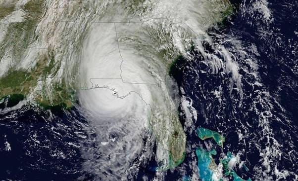
When Hurricane Michael roared onto northwest Florida’s Gulf Coast in October 2018, its 160 mile-per-hour winds made it the strongest storm ever to hit the region. It was only the fourth Category 5 storm on record to make landfall in the United States.
Thousands of residents, from the coast to 100 miles inland, were left without housing, power, food or water. Schools, stores, businesses and many government buildings shut down for weeks. Hospitals had to temporarily stop services.
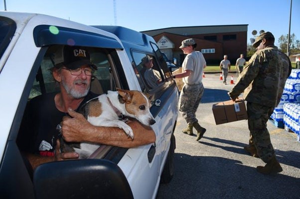
Months later, many locals were still trying to survive in battered, tarp-covered homes or living in tents, relying on local food banks for survival. Lacking customers, some business owners shuttered their doors and left town.
In Michael’s aftermath, it gradually became apparent that Florida’s Panhandle experienced more severe damage than many urban areas around the state that are relatively better prepared for behemoth storms. I have seen firsthand how this was due to lack of preparedness and infrastructure that was aging, limited and substandard.
I have studied hurricane resilience for the past 13 years and know that better preparation can help make communities more resilient in the face of major disasters. As the high-risk months approach, I and other Florida State University scholars from many different fields are working with local communities to help them get ready and improve their response plans.
Lost homes and livelihoods
After Hurricane Michael passed through, I drove to Panama City – one of the hardest-hit areas – with fellow FAMU-FSU College of Engineeringprofessors Juyeong Choi and Tarek Abichou. We made the trip to observe infrastructure and community damage and meet with local emergency management officials as part of a project supported by the federally funded Natural Hazards Center, which works to reduce harm from natural disasters.
To get there from Tallahassee, we drove west on State Road 20, an inland route that took us through ravaged rural areas. We returned along U.S. Highway 98, a scenic road that hugs the Gulf of Mexico, stopping at Mexico Beach – a small coastal tourist town that was nearly wiped awayby Hurricane Michael’s winds and storm surge.
The damage we saw was beyond anything we had imagined. There were hundreds of thousands of downed trees and hundreds of blocked roadways. Numerous houses and farms were completely destroyed, along with extensive timber plantations – the region’s big money-producing crop.
FSU planner-in-residence Dennis Smith, who has worked for decades in emergency management in the public and private sectors, was just as stunned. “The damage, both the magnitude and the geographic extent and intensity, was some of the worst I had ever seen,” he told me. “There are extensive housing losses (far inland) and the damage to woodlands is like nothing I’ve ever seen.”
The social impacts were equally daunting. “We were especially not prepared for the numbers of homeless,” said Ellen Piekalkiewicz, who directs a center focusing on the needs of communities, families and children at FSU’s College of Social Work. In the schools, she said, “there have been a number of kids having psychological problems.”
Planning for the next big storm
It is extremely challenging to prepare for very fast Category 5 hurricanes like Hurricane Michael. Storms of this size generate extreme winds and storm surge that knock out communications – including cellphone towers – and transportation routes. But proactive planning and community-level decision making can ensure that no one is left without assistance.
One essential step is identifying critical escape and emergency response routes, which are at high risk of disruption during these disasters. Pinpointing these routes in advance provides time to improve roadway infrastructure and develop alternative public evacuation plans in case primary routes are blocked.
It also is important to assess which demographic and socioeconomic groups will be most affected by damage to power lines and roadways – for example, aging populations. Studying power outages and roadway closures during hurricanes, together with a region’s physical features, reveals vulnerable locations that will be at high risk in future events.
My engineering colleagues and I also are studying how uncertainty about storm tracks affects evacuation planning and how wind damage to buildings varies with different types of terrain. These are crucial questions for storm preparedness.
#HurricaneMichael just hours away from a catastrophic, unprecedented #Florida Panhandle, Big Bend Cat. 4 landfall. *Last chance* to get to a safe place, if told to evacuate. No long-time resident of the area has ever experienced a #hurricane this intense.
Another high priority is identifying and supporting at-risk populations. Especially in rural areas like Florida’s Panhandle, planners need good information on population size, location and composition. The most effective way to collect it is by working with nonprofit agencies, volunteer groups, faith-based organizations, community-based centers, neighborhood-level groups, hospitals and governmental organizations.
“Involving these entities in hurricane training exercises is also important to build trust,” FSU public administration professor Richard Feiock told me. “That makes communities stronger and more durable when a hurricane hits.”
One promising strategy we have identified through focusing on the needs of vulnerable groups is repurposing existing hurricane shelters to serve evacuees with pets or other special needs. Experience has shown that some people will remain in harm’s way instead of evacuating if they think leaving means abandoning their pets.
Getting the word out
Communities also need to develop systems for alerting residents about hurricane risks and getting accurate information to them as quickly as possible when a storm threatens. Such networks can include radio, TV, phone and even door-to-door notification. In rural areas it is especially important to design strong community training programs, and to foster strong social networks that draw on neighbor-to-neighbor ties and other personal connections.
Hurricane warning information should include locations and types of shelters, along with dates, times and locations for pickups if transportation is available, and should explain what people can bring with them. Our research indicates that with these improvements, Panhandle communities and others like them can develop better emergency plans that reduce the stress of evacuations, provide safe shelter and ultimately save lives.
____________________
Eren Erman Ozguven is Assistant Professor of FAMU-FSU College of Engineering, affiliate of the Institute for Successful Longevity, Pepper Institute on Aging and Public Policy and the Center for Advanced Power Systems, Florida State University. His essay was originally published in The Conversation.
“How Rural Areas Like Florida’s Panhandle Can Become More Hurricane-Ready” by Eren Erman Ozguven is licensed under a Creative Commons Attribution-NoDerivatives 4.0 International License
