
12 Contour Lines
Elizabeth Johnson
Learning Objectives
Students will be able to:
- Define contour line and contour interval.
- Describe the rules of contour lines.
Overview of Contour Lines
Watch this video which explains many of the concepts of contour lines. We will use many of these concepts in this module.
Contour Lines and Contour Interval
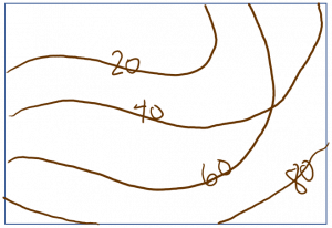
Figure 6 shows a portion of a modern topographic map. The brown lines are contour lines.

On topographic maps, each contour line connects points at the same elevation. The contour interval is the difference in elevation between adjacent contour lines.
The elevation for each contour line is sometimes marked on the line. To avoid clutter, not every contour is labeled. The elevation of an unlabeled contour line can be determined by knowing the contour interval and looking at adjacent contour lines. The elevation of a point located in between two contour lines can be estimated by interpolating between the lines. If a point is halfway between two contour lines, it will be about halfway between the elevations of those two contour lines.
In the US, standard topographic maps have elevation marked in feet above mean (average) sea level. However, international maps and maps of elevation of the ocean floor (bathymetry) are often marked in meters.
There are a couple of clues that will help you determine the elevation units on a map. First, the legend or information around the rim of the map may say something like “contour interval = 20 feet” or “contour interval = 20 meters.” Maps that use units of feet for elevation may mark contour lines with units such as 400′. The ‘ indicates units of feet.
Rules of Contour Lines
- Every point on a contour line is of the exact same elevation. In other words, contour lines connect points of equal elevation.
- By definition, contour lines separate points of higher elevation from points of lower elevation. This means it is always possible to define an “uphill” direction on one side of a contour and a “downhill” direction on the other side.
- Contour lines never cross. They may come very close to each other (e.g. along a cliff), but by definition they may never cross each other.* This is because one location on the surface of Earth cannot be at two different elevations!
- Contour lines never split. Instead, contours form closed loops. These loops follow the shape of the land, and may extend past the edge of the map.
- Closely spaced contours indicate a steep slope, whereas contours that are spaced far apart indicate a gentle slope or almost flat surface.
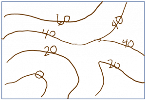
*There is one exception to this- an overhanging cliff!
References
http://www.iupui.edu/~geogdept/g108/lab_3.htm
