
53 The Grand Canyon
Elizabeth Johnson
Geologic Map of the Bright Angel Quadrangle
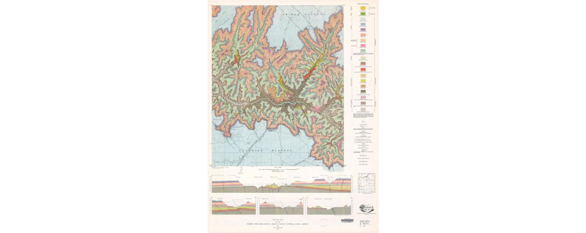
Use this link to zoom in and pan around the map: https://ngmdb.usgs.gov/ngm-bin/pdp/zui_viewer.pl?id=56217
This is the link to the map page: https://ngmdb.usgs.gov/Prodesc/proddesc_33640.htm
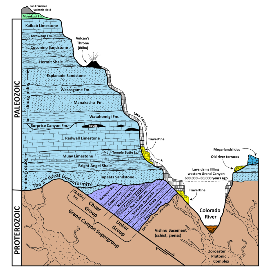
The Grand Canyon stratigraphic cross-section: https://azgs.arizona.edu/photo/grand-canyon-stratigraphy
Questions
Please use the map and stratigraphic diagram above to answer the following questions.
This diagram showing a river valley or canyon cutting down through horizontal beds should be helpful in understanding the Grand Canyon map.
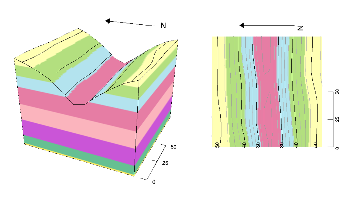
Interactive canyon diagram: http://app.visiblegeology.com/model.html#ahFzfnZpc2libGUtZ2VvbG9neXIPCxIFTW9kZWwYiZ3flgEM
17. Locate the Kaibab Plateau region in the top (north) central part of the map. It is light blue in color. What is the dip angle of the rocks (in degrees) in the area of Outlet Canyon in the Kaibab Plateau?
- 3 degrees (nearly horizontal)
- 15 degrees
- 30 degrees
- 85 degrees (nearly vertical)
18. What is the relief (change in elevation) from the “O” in Outlet Canyon, to the Colorado River? (Hint: Topography and Bathymetry)
- about 8000 feet
- about 5500 feet
- about 2500 feet
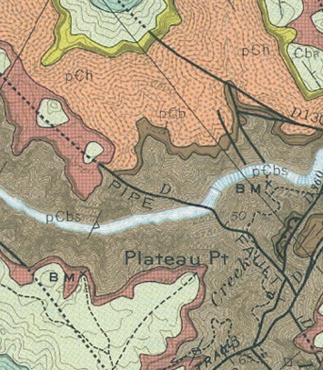
19. What type of unconformity is present between the Brahma Schist and the Bass Limestone? Hints: Look near the Pipe Fault for these units, think about what type of rock each is and review Unconformities
- disconformity
- nonconformity
- angular unconformity
20. What type of unconformity is present between the Upper Precambrian rock units (such as the Shinomo Formation and Bass Limestone) and the Cambrian rock units like the Tapeats Sandstone? Hint: check the strike and dip in the Shinomo Formation on the map, and the stratigraphic cross-section for help).
- disconformity
- nonconformity
- angular unconformity
Interactive Geologic Map
The Geologic Map of the Grand Canyon is online and interactive. If you hover over a geologic unit, you can read the name and symbol for that unit:
https://azgs.arizona.edu/interactive-geologic-map-grand-canyon
Tour the Grand Canyon
Google Maps has recorded Google Street View on many of the trails in the Grand Canyon. They also recorded street view in a boat ride down the canyon! It is easy to take a virtual field trip / hike!
Start at the South Rim on this map, and drag the orange person icon onto one of the trails to view the rocks from inside the canyon!
https://goo.gl/maps/vCwvK5U4t3oikhV89
Here’s a view of the Vishnu Schist at the bottom of the canyon: https://goo.gl/maps/RNXs2ZwH2NxqifYF7
