
15 Scale and Slope
Elizabeth Johnson
Learning Objectives
Students will be able to:
- Identify the scale of a topographic map.
- Use a scale bar to determine distance on a map.
- Use the distance and relief between two locations to calculate the average slope of the land between those two points.
Scale
All maps are a scaled-down version of the region of the world that they depict; if this were not the case, then the map that a person must carry would be the exact same size as a city (if it is a city map) or the size of a state (if it is a state map). Imagine trying to carry around with you a map of the entire country!
The word “scale” refers to the amount of reduction, and all maps provide a map scale to indicate how much the area on the map has been reduced. Map scales are provided so that a map reader can determine exactly how much distance is actually represented on their map, or to measure the distance between two points on a map, or even to calculate the gradient of a hill or river. The two commonly used map scales on a topographic map are the bar scale (or graphical scale) and the fractional scale (also known as a ratio scale).
In Figure 17 there are three bar scales; each bar is a graphical representation of distance on the map, and it is up to the map reader to decide if they want to measure distances in kilometers, meters, miles, or feet. To find the distance between any two points on a map, a person could use a piece of paper to transfer the two points down to the bar scale and read the distance directly from the bar scale. Notice that each bar scale has the starting point (zero) within the interior of the scale, and not on the end of each scale (Figure 17).
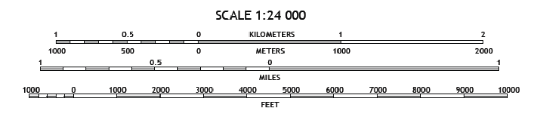
The other type of map scale is the fractional scale; in Figure 17 the fractional scale is 1:24,000. No units are reported as this ratio of 1 to 24,000 is valid for any unit of measure, provided that it is the same unit. For example, if using inches, then this map scale indicates that 1 inch on the map is actually covering 24,000 inches of ground (the distance between two locations in the real world). Or if using centimeters, then 1 centimeter on the map is actually covering 24,000 centimeters of the ground. If our map was the same size as the area that it is representing (say, for example, a map of the room you are currently sitting in), then the fractional scale of your map would be 1:1, and your map would be the exact same size as your room!
There are 12 inches in a foot and 5,280 feet in a mile. Therefore, there are 12×5,280 = 63,360 inches in a mile.
1 inch on a 1:24,000 scale map = 24,000 inches in real life. So, 1 inch on the map = 24,000 inches/63,360 inches/mile = 0.3788 miles in real life.
Determining Slope
In a previous section (Topographic Features ) we learned how to tell the difference between a steep slope like a cliff (closely spaced contour lines) and a nearly flat surface like a plain (widely spaced contour lines). We can compare the steepness of surfaces by calculating a value for the slope between two points on Earth’s surface.
Slope Equation
To determine the slope between point A and point B on a map, where point A is higher than point B:
Slope = rise / run
Slope = (elevation of point A – elevation of point B in feet)/(distance between point A and B in miles)
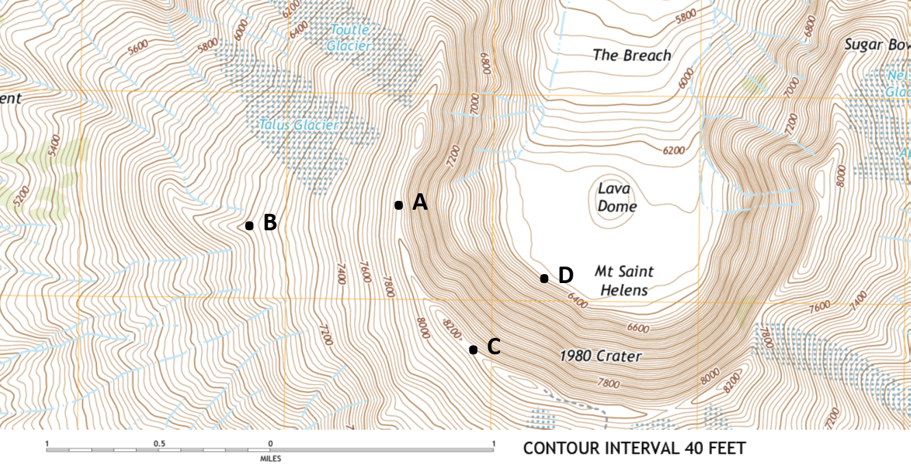
To determine the distance between point A and point B in Figure 19, use a piece of paper and transfer the miles scale (in 0.1 mile intervals) to the paper from your screen. Then, measure the distance between A and B using your paper ruler. You should get about 0.68 miles as the distance between A and B.
References
Some text from LibreTexts Laboratory Manual for Introductory Geology, CC-BY-SA-3.0 (https://geo.libretexts.org/Bookshelves/Ancillary_Materials/Laboratory/Book%3A_Laboratory_Manual_For_Introductory_Geology_(Deline%2C_Harris_and_Tefend)/03%3A_Topographic_Maps/3.2%3A_Map_Orientation_and_Scale)
