24 Plate Boundaries
Elizabeth Johnson
Learning Objectives
Students will be able to:
- Use plate motion vectors on either side of a plate boundary to determine the type of plate boundary.
- Describe reference frames for relative and “absolute” plate motion.
- Describe the locations of earthquakes and volcanoes at different types of plate boundaries.
Measuring Plate Tectonics
Reference Frames
In addition to the discussion of plate motion reference frames in the UNAVCO video above, please read this site:
https://www.unavco.org/software/visualization/GPS-Velocity-Viewer/GPS-Velocity-Viewer-frames.html
When we try to determine the type of plate boundary in between two GPS stations, it can be useful to change the reference frame to hold one plate still and look at the motion of the second plate relative to that first plate.
Two Ways to View Plate Velocities
There are two ways to view plate velocities online (without downloading Google Earth Pro).
The first method is to navigate to this site: https://sideshow.jpl.nasa.gov/post/series.html
At the top of the page, there is an embedded Google Map with plate velocities. These are relative to a worldwide reference frame.
The second method is to use the UNAVCO site: UNAVCO Plate Boundary Viewer: https://www.unavco.org/software/visualization/GPS-Velocity-Viewer/GPS-Velocity-Viewer.html
Please be patient with this- it will load!
Before you start, watch this YouTube tutorial on how to use the UNAVCO Plate Boundary Viewer:
The default reference frame is plate motion relative to the North American plate: GNSS Data Source N America NAM14 UNAVCO at the top right.
To change to a world reference frame like the data we were using previously, go to: World IGS08/NNR, GEM GSRM. Then click “Draw Map” to update it.
Plate Boundaries, Earthquakes, and Volcanoes
The UNAVCO site allows us to add the plate boundaries, as well as earthquakes and volcanoes. This works best when you are zoomed in to a location or region.
Use the UNAVCO Plate Boundary Viewer: https://www.unavco.org/software/visualization/GPS-Velocity-Viewer/GPS-Velocity-Viewer.html and go to the coast of Chile in South America (Google Santiago, Chile if you need to find the location first).
In the right-hand menu, choose: More types of data, Display plate boundaries. Then click the Draw Map button at the bottom. The plate boundary color codes are in the legend at the bottom left below the map.
Question 15: What type of plate boundary lies off the coast of Chile?
- Subduction zone (convergent)
- Oceanic spreading rift (divergent)
- Continental transform fault (transform)
Now, add the volcanoes to this region. In the right-hand menu, choose: More types of data, Display volcanic centers AND Display volcanic labels. Then click the Draw Map button at the bottom.
Question 16: Most of the volcanoes in this area of South America occur to the ____ of the plate boundary.
- West
- East
- North
- South
It is also possible to view the earthquakes in this region. In the right-hand menu, remove the volcanoes (but keep the plate boundaries), then choose: More types of data, Display earthquakes AND in Earthquakes area choose: Global. Then click the Draw Map button at the bottom.
The size of the earthquake symbol is proportional to the magnitude of the earthquake. The color of the earthquake symbol is coded to the depth of the epicenter of that earthquake.
Here is a cross-section through Chile (West on the left, East on the right) showing the earthquakes as a function of depth.
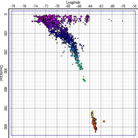
Question 17: The shallow earthquakes in Figure 20 occur in the continental crust (0-40 km depth). The deeper earthquakes outline a feature in the Earth. What is that feature? (Hint: look at the models of plate boundaries in Motion at Plate Boundaries)
- A subducted slab
- A mid-ocean rift zone
- A rift valley on a continent
