
20 Global Positioning System
Elizabeth Johnson
Learning Objectives
Students will be able to:
- Describe how GPS works.
- Describe the concept of a GPS array for measuring plate motion.
Why Use GPS for Plate Motions?
Nowadays, we use global positioning system (GPS ) technology for many things. Most of us have experienced using GPS navigation in a car to drive to a destination. Our smart phones can be GPS enabled so that apps know our location to provide us with local information such as the weather forecast or local dining options.
GPS is used in many applications in the geosciences, including volcano monitoring, groundwater monitoring, and monitoring melting of glaciers. For this class, we are interested in learning how scientists use GPS to track the motion of tectonic plates!
This section covers some basic background about GPS technology. if you are interested in learning more about the technology (optional), please see the references at the end of this page.

Figure 5. Geodetic GPS station P311 atop the Sierra Nevada mountains at Coyote Ridge, at an elevation of 3,699 meters, near Bishop, California. This station and many others show that these mountains are currently uplifting at 1–2 millimeters per year. Image courtesy of Shawn Lawrence, UNAVCO. https://www.earthscope.org/articles/exploring_continent_with_PBO.html
What is GPS and How Does IT Work?
Read pages 21-24 of this .pdf document:
https://www.nh.gov/nhdfl/documents/introduction-to-global-positioning-system.pdf
Here is a short video visualizing how triangulation works with GPS satellites:
What is a GPS Ground Network?
Scientists interested in studying plate motion have installed arrays of GPS units across many of the continents. To measure the minute changes in location over time, these GPS usints must be firmly attached into the ground surface. They are often deployed in remote areas, meaning they need solar panels, batteries, and satellite internet to run the instrument and transmit data (Figure 6).
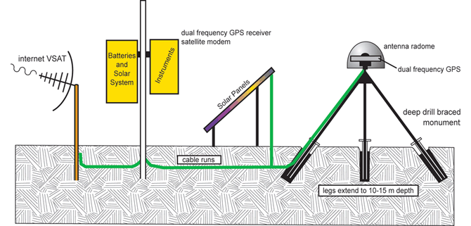
Figure 6. A GPS monument station used by the EarthScope Plate Boundary Observatory. (https://spotlight.unavco.org/how-gps-works/gps-basics/gps-and-geosciences_files/GPSStationDiagram.gif.)
This site shows maps of GPS arrays from many countries:
https://spotlight.unavco.org/how-gps-works/gps-basics/gps-ground-networks.html
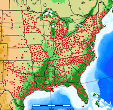
Figure 7. Continuously Operating Reference Station (CORS) mainly provides data from the eastern United States. (https://spotlight.unavco.org/how-gps-works/gps-basics/gps-ground-networks_files/CORS.png)
References
Additional detailed materials on GPS technology can be found on these sites:
https://spotlight.unavco.org/how-gps-works/gps-basics/gps-basics.html
https://spotlight.unavco.org/how-gps-works/gps-basics/satellites-controllers-users.html
https://spotlight.unavco.org/how-gps-works/gps-basics/decoding-the-gps-signal.html
https://spotlight.unavco.org/how-gps-works/gps-basics/gps-and-geosciences.html
This material is based in part on materials from the GAGE Facility, operated by UNAVCO, Inc., with support from the National Science Foundation and the National Aeronautics and Space Administration under NSF Cooperative Agreement EAR-1724794.
