48 Reading a Geologic Map
Elizabeth Johnson
What symbols and features are included on geologic maps?
Below are summarized some of the important data and interpretations to look for on a map. Many of these should be familiar from earlier labs!
Please carefully read through this page and review the materials linked in the text. You will need to be able to interpret these features on the geologic maps that follow.
Distance Scale
In an earlier chapter, Scale and Slope, we learned about scales on topographic maps. All geologic maps will also include scale.
Latitude and longitude
In an earlier chapter, we learned about Latitude and Longitude on topographic maps. Geologic maps also have latitude and longitude marked along the edges of a map, as a way to help locate positions on the map. This is much easier to do when you have a paper map in front of you, so we may locate points of interest in a different way (with geographic names or points marked on the map) for these exercises.
Topographic Contour Lines
Some geologic maps include Contour Lines: the topographic map is essentially superimposed on top of the geologic map. For clarity, other geologic maps omit the topography so the geologic features are more easily viewed.
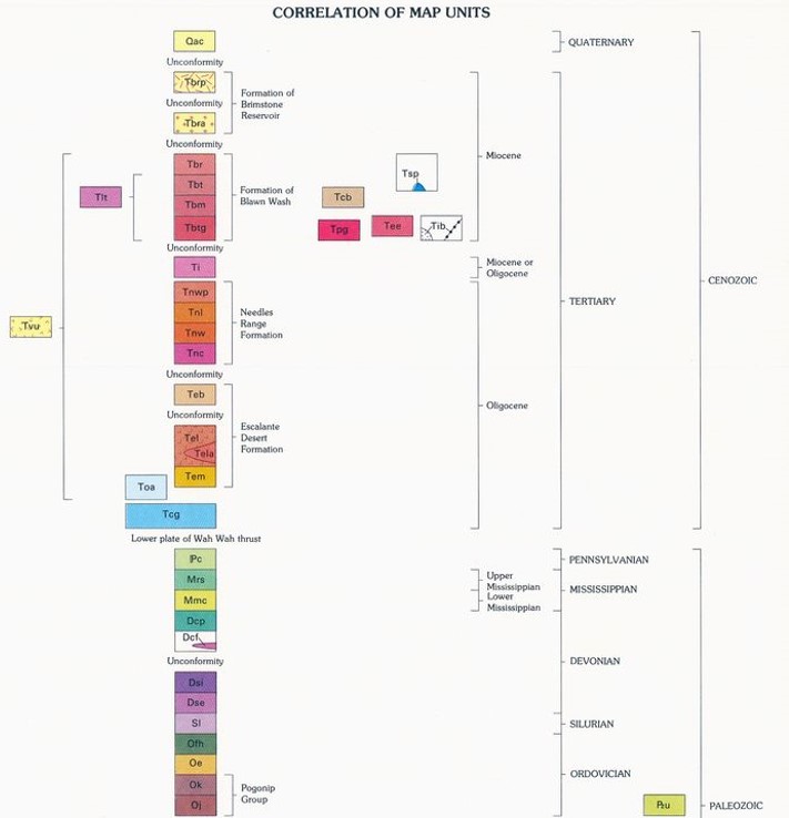
Legend with Rock Units / Formations
In a geologic map, each rock unit is given a unique color and symbol (Figure 3). This key is provided in the legend of the map. The rock units are organized stratigraphically, with the oldest rock unit on the bottom and the youngest rock unit on top. The rock unit abbreviations will often begin with a letter or letters that indicate the geologic time period or era for that rock (see Geologic Time Scale Abbreviations below).
Geologic Time Scale Abbreviations
We have already discussed The Geologic Time Scale in an earlier module (click on the link to review).
However, this geologic time scale may be more useful for this exercise, because it includes the symbols used for each geologic period or era.
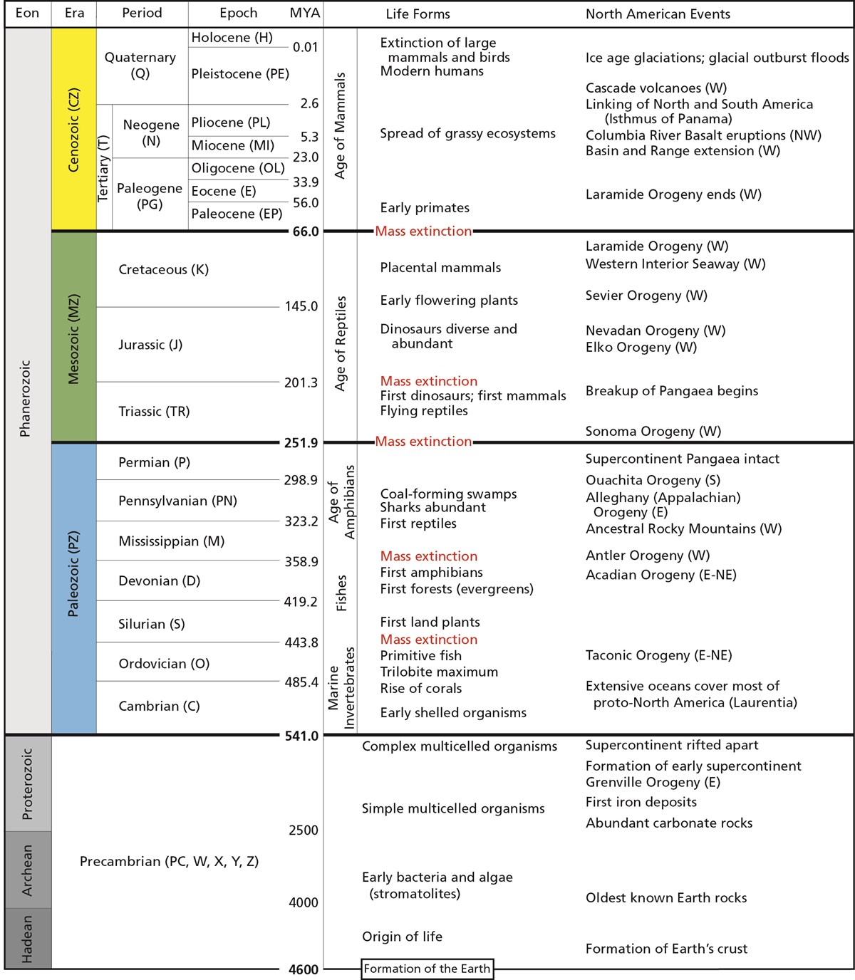
Click on this link to open this geologic time scale in a new window, for ease of use. https://www.nps.gov/subjects/geology/time-scale.htm
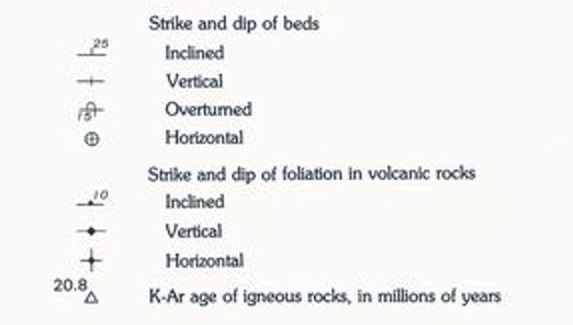
Strike and Dip
Geologic maps include strike and dip symbols showing the orientation and slope of rock beds, which we covered in an earlier lab (see Tilted Beds and Strike and Dip).
Some geologic maps also show the orientation of the foliation in metamorphic rocks with special foliation strike and dip symbols.
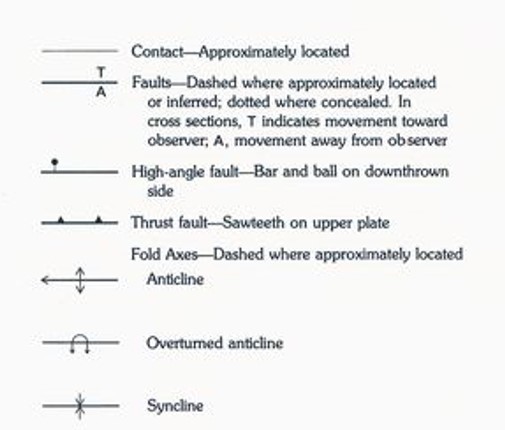
Geologic Structures
Faults are marked on geologic maps with bold lines. These lines are broader than the lines used to mark contacts between rock units. Where geologists have been able to interpret the type of fault, additional symbols may be used to indicate if it is a thrust fault, a high-angle fault (normal or reverse), or even a strike-slip fault (usually shown with arrows on either side of the fault). See Faults to review the types and geometries of faults.
Folds can be (but are not always) marked with their hinge line on the map. Plunging folds include an arrow on the hinge line marking the direction of plunge. Anticlines can be marked with two smaller arrows on either side of the hinge, pointing away from the hinge line. See Folds and Plunging Folds to review the types and geometries of folds.
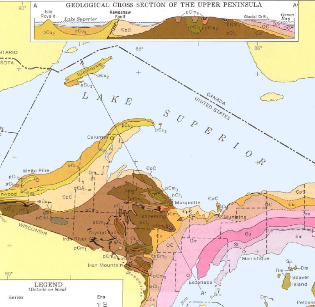
Geologic Cross Sections
Many geologic maps include geologic cross-sections, or profiles of the extrapolated geologic structures and rock units beneath the surface. The geologic structures block diagrams and topographic profiles are examples of cross-sections that we have already covered.
A geologic cross-section will be labeled on the map itself with a bold line and letters marking either end of the cross-section, usually with A-A’, B-B’, etc. Some geologic maps have multiple cross-sections, and will include all of these on a separate page or on an expanded map sheet.